
Of all the year-round-open huts in the High Tatras, this one lies the highest — by the Five Spiš Tarns in the Malá Studená Valley. Until 1933 it was even the highest-situated hut in the entire High Tatras.
Route length
9.2 km one way
18.3 km round trip
18.3 km round trip
Elevation gain
805 m
Time (one way)
~3:15 h
Difficulty*
3/5
Trailhead
Hrebienok (1,285 m a.s.l.)
📍 GPS parking
N 49.14108°, E 20.22142°
🔗 Route on Mapy.com
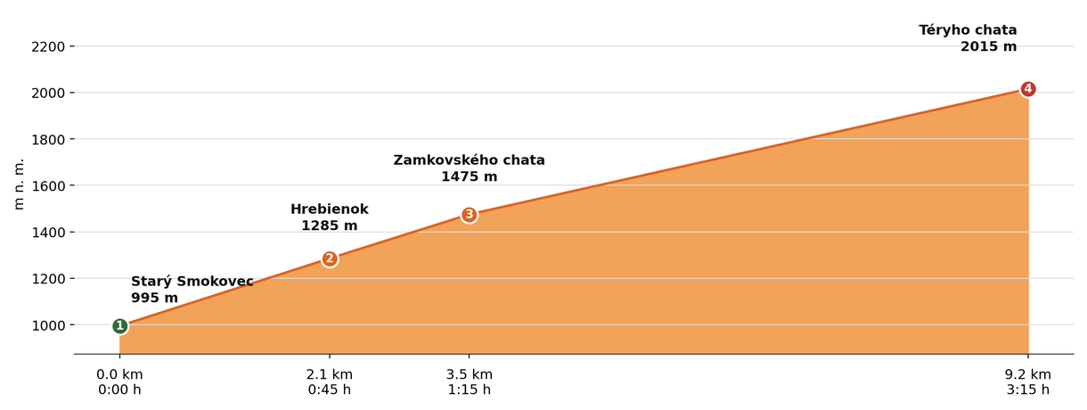
Elevation profile (podľa publikovaných dát trasy, nie z GPX)
Route breakdown
| 1 · Starý Smokovec 995 m · 0.0 km · 0:00 h | Starting point — the route begins here. |
| 2 · Hrebienok 1285 m · 2.1 km · 0:45 h | The route passes by Hrebienok, where you can rest and refill water. |
| 3 · Zamkovského Hut 1475 m · 3.5 km · 1:15 h | The route passes by Zamkovského Hut, where you can rest and refill water. |
| 4 · Téryho Hut 2015 m · 9.2 km · 3:15 h | Téryho Hut — the end of the route. |
ℹ Practical info
| 🅿 Parking | Starý Smokovec — paid car park |
| 🚻 Toilets | In the hut (cold water) |
| 💧 Water | At the hut, cold only |
| 🛏 Accommodation | 24 beds, ~€28/person with breakfast |
| 🚡 Cable car | Yes, to Hrebienok (shortens the route by 45 min) |
| ❄ Operating season | Year-round |
| ☀ Best time | June — October |
| 🧭 Orientation | Marked trail via Zamkovského Hut |
| 🎨 Trail marking | 🟢 green (Starý Smokovec → Hrebienok), 🔴 red (→ Zamkovského Hut), 🟢 green (→ Téryho Hut) |
| 🔀 Alternative route | It connects directly to Zbojnícka Hut via Priečne Saddle and the Sesterské Tarns (yellow trail) — an alternative to the approach from Hrebienok via the Malá Studená Valley. The route Téryho Hut → Priečne Saddle → Zbojnícka Hut is approx. 3 h with ~372 m of ascent; closed from 1 Nov to 31 May. |
| 🚨 Emergency number | Mountain Rescue Service: 18 300 (or 112) |
What to bring
🎒 Hiking boots
🎒 Trekking poles
🎒 Waterproof jacket
🎒 Water (min. 1.5 l)
🎒 Cash (not everywhere accepts cards)
🎒 Map / GPS / phone
⚠ What to watch out for
- Opening hours and accommodation availability may vary by season — check the current status directly on the hut's website.
- In winter and spring the access route may be closed or avalanche-prone — check the forecast and avalanche situation.
- The hut may be fully booked, especially on weekends in season — we recommend booking accommodation in advance.