← Back to saddles
Priečne Saddle
▲ 2352 m a.s.l.
One of the most demanding marked crossings in the High Tatras — it connects the Malá and Veľká Studená Valleys between Téryho Hut and Zbojnícka Hut. It has been walked in both directions since 2013.
Route length
10.0 km one way
20 km round trip
20 km round trip
Elevation gain
1,067 m
Time (one way)
~8:20 h
Difficulty*
5/5
Trailhead
Hrebienok (1,285 m a.s.l.)
📍 GPS parking
N 49.14108°, E 20.22142°
🔗 Route on Mapy.com
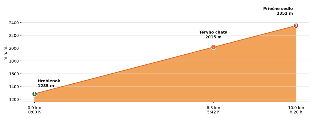
Elevation profile (podľa publikovaných dát trasy, nie z GPX)
Route breakdown
| 1 · Hrebienok 1285 m · 0.0 km · 0:00 h | Starting point — the route begins here. |
| 2 · Téryho Hut 2015 m · 6.8 km · 5:42 h | The route passes by Téryho Hut, where there is a chance to rest and refill water. |
| 3 · Priečne Saddle 2352 m · 10.0 km · 8:20 h | Priečne Saddle — the end of the route. |
ℹ Practical info
| 🅿 Parking | Starý Smokovec — paid car park |
| 🚻 Toilets | Téryho Hut or Zbojnícka Hut |
| 💧 Water | Téryho Hut (cold water) |
| 🏠 Hut | Téryho Hut and Zbojnícka Hut (on the route) |
| 🚡 Cable car | Yes, to Hrebienok |
| ❄ Ascent season | Closed 1 Nov – 31 May (section Téryho Hut – Priečne Saddle – Zbojnícka Hut) |
| ☀ Best time | June — October |
| 🧭 Orientation | A very demanding section, exposed spots secured with chains, the descent by Dlhé Tarn requires caution |
| 🎨 Trail marking | 🟢 green (Hrebienok → Téryho Hut), 🟡 yellow (→ Priečne Saddle) |
| 🔀 Alternative route | You can also reach it from Zbojnícka Hut (via the Veľká Studená Valley from Hrebienok) instead of from Téryho Hut — the same connecting link via the Sesterské Tarns, yellow marking, about 3 h, ~372 m of ascent in the opposite direction; the route is closed from 1 Nov to 31 May. |
| 🚨 Emergency number | Mountain Rescue Service: 18 300 (or 112) |
What to bring
🎒 Sturdy hiking boots with a stiff sole
🎒 Trekking poles
🎒 Helmet (recommended on exposed rocky sections)
🎒 Waterproof and windproof jacket
🎒 Extra warm layer
🎒 Water (min. 2 l)
🎒 Food / energy bars
🎒 First aid kit
🎒 Map / GPS / phone
⚠ What to watch out for
- The section below the saddle tends to be steep, rocky and in places exposed — suitable footwear and experience matter.
- Weather in high-mountain terrain changes very quickly — turn back in a storm, fog or high wind; a ridge is no place to wait it out.
- In winter and spring this terrain carries a high avalanche risk — don't come here at that time without experience and the right gear.
- There is no water available along the route — bring an adequate supply in advance.