← Back to peaks
Jahňací Peak
▲ 2229 m a.s.l.
The easternmost peak of the High Tatras, once known as Biely štít (White Peak), with views reaching as far as the Belianske Tatras and the Polish side. The route to the summit passes the Chata pri Zelenom plese (Brnčalka) hut and crosses Kolový Priechod, where a short chained section must be negotiated.
Route length
9.8 km one way
19.6 km round trip
19.6 km round trip
Elevation gain
1,420 m
Time (one way)
~5:00 h
Difficulty*
4/5
Trailhead
Biela Voda (910 m a.s.l.)
📍 GPS parking
N 49.18691°, E 20.29171°
🔗 Route on Mapy.com
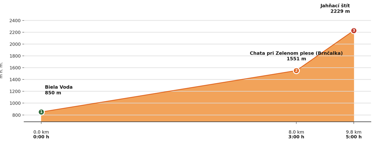
Elevation profile (podľa publikovaných dát trasy, nie z GPX)
Route breakdown
| 1 · Biela Voda 850 m · 0.0 km · 0:00 h | Starting point — the route begins here. |
| 2 · Chata pri Zelenom plese (Brnčalka) hut 1551 m · 8.0 km · 3:00 h | The route passes by the Chata pri Zelenom plese (Brnčalka) hut, where you can rest and refill water. |
| 3 · Jahňací Peak 2229 m · 9.8 km · 5:00 h | Jahňací Peak summit — the end of the route. |
ℹ Practical info
| 🅿 Parking | Biela Voda — paid car park |
| 💧 Water | Available to refill at Brnčalka |
| 🏠 Hut | Chata pri Zelenom plese / Brnčalka (on the route) |
| 🚡 Cable car | No |
| ❄ Ascent season | 1 Nov – 31 May closure (the section above Brnčalka) |
| ☀ Best time | June — October |
| 🧭 Orientation | Marked trail, a short approx. 30 m section with chains below Kolový Priechod |
| 🎨 Trail marking | 🟡 yellow (whole route, Biela Voda → Chata pri Zelenom plese/Brnčalka → via Kolový Priechod → summit) |
| 🔄 Descent | Same route back |
| 🔀 Alternative route | It can also be climbed from Skalnaté pleso (reachable by cable car from Tatranská Lomnica) instead of from Biela Voda — 🔴 red (Skalnaté pleso → saddle → Veľká Svišťovka, 2,037 m a.s.l., a steep section secured with chains), then 🔴 red (a long descent to Chata pri Zelenom plese / Brnčalka), followed by 🟡 yellow (the classic ascent around Červené pleso to the summit; the final section below Kolový Priechod is steep and chain-secured). Descent is usually the same way back via Zelené pleso and Veľká Svišťovka to Skalnaté pleso, or directly down into the valley (~1,090 m of ascent from Skalnaté pleso, approx. 5 h climb). |
| 🚨 Emergency number | Mountain Rescue Service: 18 300 (or 112) |
What to bring
🎒 Hiking boots
🎒 Trekking poles
🎒 Helmet (recommended on chains and exposed terrain)
🎒 Waterproof jacket
🎒 Water (min. 2 l)
🎒 Food / energy bars
🎒 First aid kit
🎒 Warm layer
🎒 Map / GPS / phone
⚠ What to watch out for
- Weather in the Tatras changes quickly — check the forecast and turn back if a storm approaches.
- In winter and spring (1 Nov – 31 May) the upper sections of the trail may be closed — check current conditions at tatry.sk or hzs.sk.
- Bring an adequate supply of water — refill points may not be available on high-mountain routes.