
It lies directly on the main ridge of the High Tatras between the Poľský Hrebeň ridge and the Prielom saddle, and this central position gives it one of the most comprehensive views of the range: Rysy and Vysoká to the west, Gerlachovský Peak to the south, Bradavica and Slavkovský Peak to the southeast, the Veľká Studená Valley with Lomnický and Ľadový Peaks to the east, and Svišťový Peak to the north.
Route length
8.1 km one way
16.1 km round trip
16.1 km round trip
Elevation gain
1,438 m
Time (one way)
~5:00 h
Difficulty*
4/5
Trailhead
Tatranská Polianka (1,005 m a.s.l.)
📍 GPS parking
N 49.12297°, E 20.18531°
🔗 Route on Mapy.com
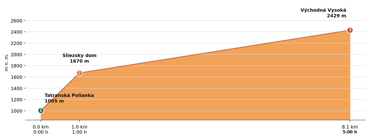
Elevation profile (podľa publikovaných dát trasy, nie z GPX)
Route breakdown
| 1 · Tatranská Polianka 1005 m · 0.0 km · 0:00 h | Starting point — the route begins here. |
| 2 · Sliezsky Dom 1670 m · 1.0 km · 1:00 h | The route passes by Sliezsky Dom, where you can rest and refill water. |
| 3 · Východná Vysoká 2429 m · 8.1 km · 5:00 h | Východná Vysoká summit — the end of the route. |
ℹ Practical info
| 🅿 Parking | Tatranská Polianka — public car park above the church |
| 🚻 Toilets | Sliezsky Dom |
| 💧 Water | Available to refill at Sliezsky Dom |
| 🏠 Hut | Sliezsky Dom (approx. 1 h from the start) |
| 🚡 Cable car | No |
| ❄ Ascent season | 1 Nov – 31 May closure (avalanche risk) — check current status at tatry.sk or hzs.sk |
| ☀ Best time | June — October |
| 🧭 Orientation | Marked trail, a technically more demanding section with fixed chains below the Poľský Hrebeň ridge, summer snowfields |
| 🎨 Trail marking | 🟢 green (Tatranská Polianka → Sliezsky Dom → Poľský Hrebeň ridge), 🟡 yellow (→ Východná Vysoká) |
| 🔄 Descent | Same route back |
| 🔀 Alternative route | It can also be done as a loop starting at Hrebienok — via the Veľká Studená Valley and Zbojnícka Hut to the Prielom saddle, over the Poľský Hrebeň ridge to the summit, then descending via Sliezsky Dom back to Smokovec. A longer and more demanding variant (approx. 19 km, ↑1,338 m / ↓1,580 m, approx. 8:53 h according to Mapy.com); the section from Zbojnícka Hut is also secured with chains. |
| 🚨 Emergency number | Mountain Rescue Service: 18 300 (or 112) |
What to bring
🎒 Hiking boots
🎒 Trekking poles
🎒 Helmet (recommended on chains and exposed terrain)
🎒 Waterproof jacket
🎒 Water (min. 2 l)
🎒 Food / energy bars
🎒 First aid kit
🎒 Warm layer
🎒 Map / GPS / phone
⚠ What to watch out for
- Weather in the Tatras changes quickly — check the forecast and turn back if a storm approaches.
- In winter and spring (1 Nov – 31 May) the upper sections of the trail may be closed — check current conditions at tatry.sk or hzs.sk.
- Bring an adequate supply of water — refill points may not be available on high-mountain routes.